


Editor's Note: The High Park Fire started on Saturday, June 9th. Winds and high temperatures helped the fire rapidly spread. The blaze has grown from an initial 8,000 acres by the end of Saturday to an estimated 20,000+41,140 by the end of Monday. This post archives all of our updates from Monday. Our day 1 updates are archived here and our day 2 updates are archived here. The latest updates and coverage of Day 4 of the fire, Tuesday June 12th can be found at this post.
Update 8:45pm via Kirk Siegler on Twitter
Crazy skies from #highparkfire this evening pic.twitter.com/4ZT6Dgq9
— Kirk Siegler (@KirkSiegler) June 12, 2012
Update 8:40pm
Here is a PDF map of the High Park Fire.
Update 8:33pm a few pictures from this evening via Twitter
Sunset on the smoke and a distant flame (look to the bottom right) at #HighParkFire pic.twitter.com/ncCROwN0
— Jeff Todd (@CBS4Jeff) June 12, 2012
#HighParkFire behind the ridges above Horsetooth Res. Watching the slurry drops w friends whose home is on front side. pic.twitter.com/KKyzyfdJ
— Patti Westfall (@SignaramaFC) June 12, 2012
An impressive sight even though I don't really want to see it. #highparkfire pic.twitter.com/MB3IV7WD
— kegrill (@kegrill) June 12, 2012
Update 8:20pm
From Kirk Siegler at the media briefing: Larimer Sheriff says victim Linda Steadman was notified by reverse 911 twice.
Update 8:11pm
There still is no containment on the fire, it remains at 0%. Officials are hopeful that they may be able to have some containment by tomorrow morning. It is hoped another IR flight will be able to flyover the fire and gauge it's size tonight.
Update 8:08pm via Kirk Siegler on Twitter
Breaking: @LarimerSheriff confirms one fatality in #HikeParkFire - 62 yo Linda Steadman
— Kirk Siegler (@KirkSiegler) June 12, 2012
Update 8:03pm
The size of the High Park Fire is now 41,140 acres.
Update 7:58pm
The final media briefing of the day is starting soon. You can live stream it here courtesy of CBS4.
Update 5:30pm via the Larimer Sheriff on Twitter
One death has been confirmed for the #HighParkFire. Additional details tonight at 8:00 p.m. briefing.
— Larimer Sheriff (@LarimerSheriff) June 11, 2012
Update 5:24pm
KUNC is back on the air in some places in Weld and Larimer County. Temporary low power service has been restored to 91.5fm. 102.7fm in Boulder has also been restored to service.
Update 4:57pm
Dry and windy conditions are a concern all across Colorado. Boulder Sheriff Joe Pelle has expanded the fire ban in Boulder County. No open burning of any kind will be allowed in unincorporated Boulder County. If you live in and around the area you should check the list of banned activities, the penalty for a violation starts at $500 and 'escalates' from there.
Update 4:40pm
Grace Hood has an update from Monday morning's citizen briefing for those evacuated by the High Park Fire.
Update 4:19pm
There has been no change in the reported size of the High Park Fire. It remains at 36,930 Acres and at 0% containment. The official cause of the fire is lightning. From the Larimer Sheriff:
Crews are concerned with the northeast portion of the fire near Bonner Peak. Heavy helicopters are doing water drops in this area and more crews are being directed to this area.
There have been no additional evacuations or pre-evacuations called for today. The fire is no longer moving toward the northwest side of Horsetooth Reservoir, this could change though as fire conditions have been rapidly evolving since Saturday.
Update 3:45pm via Kirk Siegler on Twitter
Breaking: @LarimerSheriff confirms #HighParkFire caused by lightning
— Kirk Siegler (@KirkSiegler) June 11, 2012
Update 3:36pm via Kirk Siegler on Twitter
Nick Christensen of @LarimerSheriff says fire burning toward Bonner Pk subdivision, but not immediate threat #HighParkFire
— Kirk Siegler (@KirkSiegler) June 11, 2012
Update 3:29pm
Host Erin O'toole spoke with Kirk Siegler today during All Things Considered about the new Type 1 Team that has assumed control of fire operations today.
Update 3:07pm
As we have done with both Saturday and Sunday, here is a collection of the day's pictures from the fire gathered in a Storify. These come from in and around the fire off of social media.
Update 2:07pm
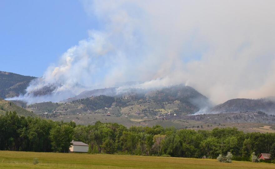
Reporter Kirk Siegler sent in a picture of the fire as seen from Bellvue, CO this afternoon. We've updated the lead photo on this post with it. Click on the photo to enlarge. Note the houses on the foothills and the encroaching fire.
Update 1:57pm
North Forty News has more on the announcement from the Larimer Sheriff that 100 homes may be damaged or destroyed. From the article:
A news release from the Sheriff’s Department confirmed that homes have been damaged or destroyed in parts of Rist Canyon, Stove Prairie, Old Flowers Road and Paradise Roads.
No details are available on the structures and there also could be damage in other locations like Soldier Canyon and Mill Canyon. Structure protection is still among the priorities for authorities today.
Update 1:29pm via the Larimer Sheriff on Twitter
Based on density of homes in the Rist Canyon area we believe approx 100 homes damaged or destroyed.Undetermined number in other areas.
— Larimer Sheriff (@LarimerSheriff) June 11, 2012
Update 1:12pm
We have established a temporary low power signal on 91.5fm that can be heard in parts of Weld and Larimer County. We have also reestablished service on 102.7fm in Boulder.
Update 12:57pm
The NOAA Environmental Visualization Laboratory has released a satellite image of the High Park Fire. The difference between this satellite picture and the previous picture we posted from NASA is this is an infrared picture. From the site:
The VIIRS sensor can use its many visible and infrared channels to differentiate between surface types. In this image, not only are the active fire areas and smoke visible, but also the different surface classifications. Vegetated areas are colored in shades of green: dark green are forested areas, bright green are grasslands. Blue areas are the snow-covered mountain peaks. Areas without vegetation (e.g., bare soil, urban areas) are colored in purple.
It is a very dramatic and interesting view of Colorado from above. It's very similar to the Digital Globe satellite shot of Buckhorn Mtn. we found on Twitter yesterday.
Update 12:19pm via Chris Spagnuolo on Twitter
The helicopters are working to protect homes on the western side of Horsetooth Reservoir from the #highparkfire: pic.twitter.com/c8gm9b0E
— Chris Spagnuolo Ⓥ (@ChrisSpagnuolo) June 11, 2012
Update 12:10pm via Sarah Jane Kyle on Twitter
Meet Bill Hahnenberg, Type 1 Incident Commander. #HighParkFire pic.twitter.com/ZBhWVRYT
— Sarah Jane Kyle (@sarahjanekyle) June 11, 2012
Update 11:57am
Incident Commander Bill Hahnenberg just spoke at the latest media briefing. Hahnenberg says the primary focus is on protecting the southern flanks of the fire where most homes are. He also warned that there is going to be a lot of fire growth due to the presence of dry fuel and the wind.
Tim Wieland of CBS4 has quoted Mr. Hahnenberg warning that "We may still be at 0% containment after today. Sometimes you just have days like that"
A bit of good news though from the media briefing as Hahnenberg says that there will soon be 600+ people fighting the High Park Fire.
Update 11:27am
Here are a few details from the 11am New Release from the Larimer County Sheriff's office:
- Type 1 management team assumed command of the fire this morning. Bill Hahnenberg is the Incident Commander.
- Homes have been damaged or destroyed in parts of Rist Canyon, Stove Prairie, Old Flowers Road, and Paradise Road areas. Some structures have been damaged or destroyed in Poudre Park but we are not sure whether there were any homes.
- Lightning is suspected to be the cause of the fire. Investigation still continues.
Also they have released an updated list of resources, this list corrects and supersedes the list we provided in our 9:52am update.
- 5 SEATS (Single Engine Air Tankers)
- 2 type 3 helicopters
- 3 type 2 helicopters
- 2 type 1 helicopters
- Air Attack control plane
- Lead plane
- 5 heavy air tankers (there are only 9 available in the nation)
- The Colorado National Guard is providing two Blackhawk helicopters for use today either for transport or bucket drops depending on the need.
Update 11:15am
The Coloradoan is now reporting that the fire is descending into Lory State Park.
Update 11:01am
NASA has released a satellite image of the High Park Fire. The lead image of this post has been updated with it. Click on the picture to enlarge it. Very noticeable smoke plume trailing off towards Wyoming and Nebraska.
Update 10:41am via Logan on Twitter
View from csu campus #Highparkfire pic.twitter.com/9vuoc2yH
— Logan (@LoganLikesThis) June 11, 2012
If you are following the High Park Fire from out of state here's a Google Map link showing Colorado State University's position in Fort Collins, CO. The High Park Fire is burning to the west of Fort Collins, and while exact fire size has been very difficult to determine with this fast growing fire, this map from Wunderground will give you some comparative information.
Update 10:31am
The High Park Fire is affecting events on campus at Colorado State University. The latest info can be found at the CSU Public Safety site.
- Summer classes on CSU's main campus are proceding as scheduled
- Preview New Student Orientation has moved indoors
- Youth Sports Camp Activities have moved primarily indoors
- Classes at Pingree Park have moved temporarily to the main campus
Update 10:29am via Colorado State University on Twitter
CSU's Vet Teaching Hospital designated to take overflow of small animals evacuated from #HighParkFire http://t.co/oGOJHYA8 @CSUVetHospital
— Colorado State Univ (@ColoradoStateU) June 11, 2012
Update 10:14am
Just overheard on the radio scanner that fire crews have reported that a "hot tub is on fire behind a home". Here's an online link to monitor scanner traffic.
Update 10:10am
The air tanker pictured below is a Lockheed P2V-7 Neptune operated by Minden Air Corp.
Update 10:04am via Jennifer Broome on Twitter
Pic fr @kdvr Sara Morris reporting fr Rocky Mtn Airpt of air tanker prepping to head to #HighParkFire. pic.twitter.com/TznNj55B
— Jennifer Broome (@JenniferBroome) June 11, 2012
Update 9:52am
Here is the list of aerial resources available to fight the High Park Fire: (this list was updated @ 11:27am)
5 heavy air tankers5 SEATs (Single Engine Air Tanker)3 heavy heli-tankers1 Blackhawk helicopter (Colorado National Guard -info)
Update 9:45am
From the media briefing: The fire grew to 36,930 acres overnight, this estimation was obtained by IR flyovers overnight. The fire continues to grow and is fuel and wind driven, thanks to dry conditions and brush, timber and grass. This is helping the fire move at 1 mile and hour.
There are 400+ fire fighters on scene and 5 heavy air tankers to fight the blaze. We hope to have a full list of resources soon as well as a map.
Update 9:26am
KUNC's Dave Dennis sent this in: taken from Bingham Hill looking towards Rist Canyon pic.twitter.com/oGSQHSty
— KUNC Colorado (@KUNC) June 11, 2012
Update 9:18am
Speaking of smoke, this was just released by Larimer County:
Due to smoke from the High Park fire, Horsetooth Reservoir, Horsetooth Mountain Open Space, and Eagle’s Nest Open Space have been temporarily closed to public use. At this point, campers who have reservations for Monday night, June 11, 2012, and/or Tuesday night, June 12, 2012, should call the reservation company at 1-800-397-7795 to change or cancel.
Update 9:02am
As you would expect this morning the air quality isn't good in Northern Colorado. The summary from the Colorado Department of Public Health and Environment has the Air Quality Index at 'Unhealthy for sensitive groups'. That falls in the 101-150 range on their scale, anything in the 301-500 range is hazardous.
Smoke is ever present right now in the Fort Collins area, it is also filtering across a large area as well. Looking around Colorado smoke is visible on several CDOT traffic cameras. Take a look at: US 287 Virginia Dale looking south, Wellington @ I-25 looking north, Crossroads Blvd. & I25 looking north, and Berthoud @ I-25 looking north.
Update 8:44am via Grace Hood on Twitter
evacuees filtering into McKee Bldg for 9 am briefing #highparkfire #TwitPict http://t.co/nrQ2Twxc
— Grace Hood (@gracehood) June 11, 2012
Update 8:40am
Here's a quick round-up of some other coverage of the High Park Fire this morning:
- Summit County firefighting teams on standby to help with High Park fire (Summit Daily)
- Colorado wildfire: High Park Fire in Larimer County now up to 36,000 acres burned (Daily Camera)
- High Park fire threat to family animals and a wolf sanctuary (From yesterday - Examiner.com)
There are also some great photo galleries from the High Park Fire and other fires at North Forty News.
Update 8:12am
Official media briefings are planned for today at 9:30am, 11:30am, 3:30pm, and 8pm. We're hoping to have many more details on the fire's growth, direction and behavior after the first update of the morning.
According to the Forest Service InciWeb site this morning, the High Park Fire is the third largest active wildfire in the country. The Honey Prairie Complex fire in Georgia is first at 309,200 acres and the Whitewater Baldy Complex fire in New Mexico is second at 278,039 acres.
Update 7:48am
We have picture collections on Storify from both Saturday and Sunday that you can review. Lots of those picture are straight off of social media from people right around or in the path of the fire as it grew.
Additionally, there is this short video from yesterday we found this morning on youtube of the High Park Fire:
http://youtu.be/JMIgsqivTHw
Update 7:39am
To give you a sense of size on the High Park Fire, which is now an announced 36,930 acres or 57.7 square miles, here are the sizes of Colorado's major cities in square miles:
- Denver, CO - 155 sq miles
- Boulder, CO - 25 sq miles
- Greeley, CO - 30 sq miles
- Loveland, CO - 26 sq miles
- Colorado Springs, CO - 186 sq miles
Update 7:35am via Kyle Saunders on Twitter
Some perspective: 36930 acres = 57.7 sq mi #highparkfire
— Kyle Saunders (@KyleLSaunders) June 11, 2012
Update 7:30am via the Larimer Sheriff on Twitter
#HighParkFire now has 400 personnel
— Larimer Sheriff (@LarimerSheriff) June 11, 2012
Update 7:27am
Breaking: The Larimer Sheriff has announced that the High Park Fire is now at 36,930 acres.
Update 7:12am
A quick reminder this morning: KUNC's main transmitter is located on Buckhorn Mtn. which is inside the High Park Fire zone. 91.5fm is currently off the air due to power loss at the site. Please keep your fingers crossed that there is also no fire damage.
Update 6:48am
Various Denver news outlets now have live feeds from a helicopter over the fire this morning
Update 6:34am
Here is a list of the current active evacuations. A reminder, the evacuation center is no longer Cache La Poudre Middle School in Laporte. It is now the McKee building at the Ranch in Loveland.
- South of CR38E to Gindler Ranch Road west to Milner Ranch Road.
- North of County Road 38E, from Horsetooth Reservoir to Redstone Canyon to Lory State park.
- Bonner Peaks subdivision.
- County Road 44H (Buckhorn Road) from County Road 27 to Pennock Pass and residents to the south approximately 3/4-1 mile, you will need to exit the area by going east on County Road 44H/Buckhorn Road.
- CR27E to Bellvue.
- Areas south and west of Bellvue to include the Lory State Park area, the Redstone Canyon area and Buckhorn Road up to the Stove Prairie School.
- Poudre Canyon from MM111 to MM118 on Highway 14. This means Poudre Canyon from Stove Prairie to MM118 is under mandatory evacuations.
- The area between CR27E and Stove Prairie Road and south through the entire Rist Canyon area including Davis Ranch Road, Whale Rock Road. South on CR44H 3 miles to just north of Stringtown Gulch Road
- Paradise Park Road, Moose Horn Lane, Magic Lane and Spencer Mountain Road.
- Old Flowers Road from Stove Prairie Road to the 8000-block of Old Flowers Road.
- Stove Prairie Road north along County Road 27 to Highway 14, east along Highway 14 to approximately mile marker 111, southeast to Rist Canyon Fire Station 1, then back west to to include Wilderness Ridge Way, Rist Creek Road, Spring Valley Road and County Road 41 and all of the roads that run off of it.
--
There is no containment of the High Park Fire. Fire crews spent Sunday focused on structure protections, firefighter and public safety, and and trying to limit the fire to a boundary area. The boundaries were north of Buckhorn Road, east of Pingree Park Road, South of Highway 14, and west of Boyd Gulch/Redstone Canyon. The fire grew quickly on Sunday though, reports surfaced at 3:20pm that the fire had jumped Highway 14. The crossing point was later identified as Picnic Rock.
Amid health concerns around smoke and ash, the evacuation center at Cache La Poudre Middle School was closed last night and moved to the McKee Building at the Ranch. Today's citizen briefings are tentatively scheduled for 9am and 3pm at the McKee Building.
According to the National Weather Service the forecast for today in the Fort Collins area calls for a high of 78°. Lighter winds are expected, becoming southeasterly between 12-15 mph with gusts up to 21 mph.


