
Friday, Oct. 23 updates
__
3:10 p.m. - Highway 40 in Grand County has reopened after being closed due to the East Troublesome Fire. Residents from mandatory evacuation areas are not yet allowed to return, however. Those returning to voluntary evacuation areas are also asked not to stay, in order to keep roads in and out of Estes Park clear for firefighters.
#EastTroublesomeFire Evac Update: If you return to or have stayed in a voluntary evac area in Estes Park, please do not stay. With limited ingress/egress to Estes, we need to ensure emergency personnel can quickly respond to evolving conditions. https://t.co/ENxiW11d28
— LETA (@LETA_911) October 23, 2020
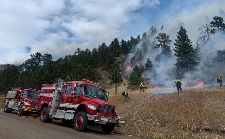
Highway 7 in Boulder County west of Lyons and east of Riverside-Raymond remains closed at New Bridge/Hall Ranch Open Space, as crews working the Cal-Wood Fire are operating firefighting apparatus in the area.
11:00 a.m. - Firefighters are crediting the cold front that moved into Boulder County on Thursday in helping them get the Cal-Wood Fire under better control. The fire is now considered 55% contained.
Firefighters plan to double down on the progress by continuing to mop up lines around controlled areas of the Cal-Wood Fire’s edge while looking for opportunities to build fire lines in the St. Vrain Canyon to prevent further spread.
The Lefthand Canyon Fire is considered 100% contained. Firefighters are expected to patrol the fire lines today and make improvements as necessary.
Officials say cool, cloudy conditions on Friday will help them manage both fires, though wind gusts as high as 25-30 mph are expected in the county. The Boulder County Sheriff’s Office modified some evacuation orders and warnings. For the latest on those, visit https://boulderoem.com or call (303) 413-7730.
A temporary forest closure remains in place for all activities on Arapaho and Roosevelt National Forests in Boulder, Larimer, Grand, Clear Creek, Jefferson and Gilpin counties. More information on those can be found at https://go.usa.gov/x7CZJ. For more information on fire-related Boulder County Parks and Open Space closures, visit https://boco.org/BCPOSfireclosures.
10:15 a.m. - Larimer County officials on Friday decided to close Reservoir Park and Open Space because of wildfire activity in the region. The decision comes after “careful monitoring and assessment,” officials said in a statement. Hermit Park Open Space is also closed. The latest on closures in Larimer County and Colorado can be found at larimer.org/naturalresources and trails.colorado.gov.
Officials in Larimer County said other areas would remain open for now, including Devil’s Backbone Open Space, Horsetooth Mountain Open Space and the reservoir (South Bay only), Blue Sky Trail, Prairie Ridge Natural Area, and Flatiron and Pinewood Reservoir.
__
Thursday, Oct. 22 updates
__
5:45 p.m. - The East Troublesome and Williams Fork fire incident management team is holding a community briefing. Watch it on Facebook Live here:
The East Troublesome Fire grew an additional 45,000 acres Thursday, and is now estimated at 170,000 acres, according to the briefing.
3:08 p.m. - In addition to the western part of Estes Park, residents in the following parts of town are now being ordered by the Larimer County Sheriff's Office to evacuate as the East Troublesome Fire continues to grow:
- Area with the north border of Peak View Drive, west border of Marys Lake Road, and south and east borders of Fish Creek Road
- Area with the north border of North St. Vrain Ave, west border of Curry Drive, south border of Acacia Drive, and east border of Fish Creek Road
Dark red skies and smoke enveloped Estes Park this afternoon as residents in cars lined up to evacuate. All roads entering the town have been closed, and are open for outbound traffic only.
This is they sky right now in Estes Park (pics via @photojmatthew) #EastTroublesomeFire pic.twitter.com/jyXLEvkJOt
— Mitchell Byars (@mitchellbyars) October 22, 2020
The Larimer Humane Society announced their partner shelter, Riverdale Animal Shelter of Adams County in Brighton, is open to pets belonging to evacuees leaving via Hwy 34 and 36. Gilpin County Fairgrounds in Black Hawk is open to large and small animals for evacuees leaving via Hwy 7.
#EastTroublesomeFire Evac Update: At this time, Larimer Humane Society is asking evacuees who are evacuating:
— LETA (@LETA_911) October 22, 2020
1. via Hwy 34 and Hwy 36 to transport your small companion animals to our partner shelter, Riverdale Animal Shelter of Adams County, 12155 Park B https://t.co/RX0XQwbND7
Residents of the town of Granby and the surrounding area are being told to prepare for evacuation as well, but a mandatory evacuation order has not yet been issued.
"If you have livestock, animals, or need extra time to evacuate, now is the time to evacuate. You do not have to wait for an Evacuation Order to leave," the Grand County Sheriff told residents in the latest update. Areas north of Granby were placed under a mandatory evacuation order at 12 p.m. today.
Areas of Boulder County that were evacuated due to the Lefthand Canyon Fire and Cal-Wood Fire near Jamestown are allowing re-entry. Closures along Lefthand Canyon Drive may prevent entry from the east. Some areas are under tiered re-entry ensuring that only residents can return to them. More information on which areas are open can be found on the Boulder Office of Emergency Management website.
1:15 p.m. - Gov. Jared Polis is providing updates on the state's response to the wildfires. Watch on Facebook Live here:
12:35 p.m. - The East Troublesome Fire has crossed the Continental Divide, prompting the Larimer County Sheriff's Office to issue mandatory evacuations on the western side of Estes Park, within the boundaries of the north border of Fall River Road, south border of Highway 36, west border of Elm Road and east border of Wonderview.
This is the Larimer County Sheriff’s Office with upgraded evacuation information. The East Troublesome Fire officials have ordered Mandatory evacuations for the western part of Rocky Mountain National Park and much of the west side of the Estes Park area. https://t.co/8BCXcncEAa
— LETA (@LETA_911) October 22, 2020
Cal-Wood and Lefthand Canyon
Firefighters increased containment on both the Cal-Wood and Lefthand Canyon fires with minimal fire growth. Crews on the southeast edge of the Cal-Wood Fire conducted a successful tactical burn operation near the Balarat Outdoor Education Center to protect structures in that area. Firefighters are continuing work in the Highway 7 corridor and along the northern edge of the Cal-Wood Fire, constructing a direct line and checking the progress of the fire to the north.
Firefighting crews were able to secure the southern edge of the Lefthand Canyon Fire on Wednesday, and are working on the north side of the fire Thursday, mopping up and improving containment lines.
The Boulder County Sheriff’s Office enacted an evacuation order for Lyons Park Estates out of an abundance of caution due to last night’s high winds and low humidity. All other evacuation orders and warnings remain in place.
Combined, the Cal-Wood and Lefthand fires have burned more than 10,000 acres.
Cameron Peak
Since the Cameron Peak Fire expanded by 70,000 acres last week, about 190 structures have been damaged or destroyed, the Coloradoan reports.
Air support is grounded Thursday due to limited visibility, but other ground operations are continuing as planned. There is no significant fire activity to report on the Cameron Peak Fire. About 1,600 firefighters are working the fire, which is currently more than 206,000 acres in size.
Weather and fuel conditions
A cold front is arriving over much of the impacted areas and will continue Thursday night. Temperatures will fall through the afternoon, dropping below freezing after sunset. Humidity will also be increasing, rising to 60-70% over the course of the day. Fire crews are hopeful the changing weather conditions will temper fire activity.
10:30 a.m. - The National Park Service has closed public access to Rocky Mountain National Park due to extreme fire behavior along the Continental Divide.
Kyle Patterson, Rocky’s spokeswoman, said in an email that the East Troublesome Fire had crossed into sections of the park’s western portion.
“If conditions allow, an infrared flight is planned to gauge where there is current fire activity,” Patterson said. “This is a rapidly evolving situation.”
Farther east, in Estes Park, local fire officials were on high alert. In a statement on Facebook, the Estes Valley Fire Protection District said its staff was monitoring the situation closely.
“We are aware of the threats around us, and we are planning to mitigate the ways they could impact us,” the post read. “Many of the mitigations have been in place for a long time, such as: redundant electric supply, redundant telecommunications fiber, adequate water supply, evacuation routes and triggers, and the list goes on.”
The U.S. Bureau of Reclamation also suspended operations of the Colorado-Big Thompson Project, a transmountain diversion that pumps water from the Western Slope to Front Range cities and farmers.
In an email, the bureau’s Victor Lee told project participants that its Adams Tunnel, which pulls water from Grand Lake, was turned off late Wednesday night because its pumping plant was being evacuated.
“There is no estimated time when the system will resume diversion,” Lee wrote in an email. “Power generation will be interrupted at all plants.”
It’s unclear what the temporary stoppage in Western Slope diversion could mean for Front Range municipalities already reeling from prolonged drought.
8:09 a.m. - The East Troublesome Fire grew to over 125,000 acres on Wednesday, according to an update on the fire's information page. It is currently 5% contained.
6:30 a.m. - The East Troublesome Fire burning in Grand County exploded in size on Wednesday, prompting hundreds of new mandatory evacuations from Grand Lake in what became the state’s latest example of extreme fire behavior this season.
An updated acreage wasn’t immediately available Thursday morning, but in a video message posted on Facebook, Grand County Sheriff Brett Schroetlin estimated the fire grew around “6,000 acres an hour.”
“It’s been an extremely, extremely challenging day for our community,” Schroetlin said. “As we drive around this part of Grand County, I don’t know what we’ll see in the morning.”
A grim update from the Grand County Sheriff. He says the fire burned 6,000 acres per hour. He said it’s been an extremely challenging day. “As we drive around the northern part of Grand County, I’m not sure what we will see in the morning to be honest.” pic.twitter.com/vczf4svrQC
— Emily Allen (@EmilyAReports) October 22, 2020
The fire, which ignited earlier this month, was fueled by high winds and dry conditions. As the flames grew Wednesday, local first responders went door to door to tell residents of Grand Lake to pack their bags and leave.
Video shared on social media showed flames glowing along a ridgeline as residents got in their cars.
#EastTroublesomeFire update. Longer version. pic.twitter.com/Hrwl8rnDis
— CarrieAnn Fain 🇺🇸 (@CarrieAnnFain) October 22, 2020
The National Park Service closed the western portion of Rocky Mountain National Park due to fire danger. Trail Ridge Road was being used for eastbound evacuations.
West side of #RMNP is closed due to significant fire activity on the East Troublesome Creek Fire outside the park. Grand Lake area residents evacuating. Trail Ridge Road is currently open for evacuation eastbound if needed. Trail Ridge Road is closed westbound at Rainbow Curve.
— RockyNPS (@RockyNPS) October 22, 2020
Air support is planned for Thursday, but high winds could impede those efforts. A red flag warning is in effect for most of the region including the high country and foothills along the Front Range.
__
Wednesday, Oct. 21 updates
__
12:00 p.m. - Fire officials across Northern Colorado are preparing for what could be another challenging day. A red flag warning is in effect for the Front Range foothills until 8 a.m. Thursday.
Paul Delmerico with the Cameron Peak Fire incident management team said the potential for more gusty winds could limit firefighting efforts.
“Public and firefighter safety are our number one priority, so if this fire picks up, and these winds do materialize we are going to be moving folks into safe places,” Delmerico said.
The Cameron Peak Fire has burned 206,009 acres and is 52% contained.
Farther south, a red flag warning is also in effect for the Cal-Wood and Lefthand Canyon fires in Boulder County. The fires’ response team is expecting dry conditions and wind gusts up to 30 miles per hour.
The Cal-Wood Fire has burned almost 10,000 acres and is 21% contained. The Lefthand Canyon fire has grown to 460 acres and is just 4% contained.
More public land closures to aid firefighting efforts were announced Wednesday. The Bureau of Land Management is closing all of its lands in Larimer and Boulder counties with exemptions for firefighting personnel and those with existing grazing permits.
Boulder County Parks and Open Space also announced closures of popular recreational areas:
- Anne U. White
- Bald Mountain
- Caribou Ranch
- Castle Rock climbing area
- Grassy Top
- Hall Ranch
- Heil Valley Ranch
- Hessie trailhead
- Mud Lake
- Reynolds Ranch
- Sugarloaf Mountain
The City of Boulder Open Space and Mountain Parks has also closed the Fourth of July trailhead.

The news comes a day after the Forest Service’s Arapaho-Roosevelt National Forest announced a wide-scale closure of its lands in Boulder, Larimer, Clear Creek, Gilpin and Jefferson counties.
Closures are still in place in Larimer County for Horsetooth Mountain Open Space, Blue Sky trailhead, Devil's Backbone, Horsetooth Reservoir, all Big Thompson parks, and both Flatiron and Pinewood Reservoirs.
__
Tuesday, Oct. 20 updates
__
3:45 p.m. - National forest land from the Colorado-Wyoming border to Mount Evans will be closed as of midnight Wednesday. The closure in the Arapaho-Roosevelt National Forest comes as existing wildfires continue to burn larger across the northern Front Range along with the risk of new fires starting.
All national forest land in Boulder, Clear Creek, Gilpin, Larimer and Jefferson Counties is included in the closure. Outside of essential fire-related personnel, no one is allowed on roads, trails or campgrounds. The agency is directing affected hunters to Colorado Parks and Wildlife for potential refunds. A Forest Service statement said the agency will review the closure daily to see if conditions improve.

“The number of large fires and extreme fire behavior we are seeing on our Forests this year is historic," said Forest Supervisor Monte Williams in a statement. "These temporary closures are necessary to protect the public and our firefighters, and we will keep them in place until conditions improve and we are confident that the risk of new fire starts has decreased.”
A Forest Service spokesperson said the expansive nature of the closure is unprecedented. The agency is unaware of a past closure that covered this much land. A 2013 closure order related to flooding was smaller in size.
The Cameron Peak Fire flared up again Tuesday afternoon in the foothills west of Loveland. Wind gusts fanned the flames near Glen Haven, and forced firefighters to move back from The Retreat and Storm Mountain. Those crews were able to re-engage the fire later in the afternoon. The incident management team overseeing the fire reported no new structure losses as part of the renewed activity. The winds also grounded helicopters being used to drop water and limited drops of retardant.
The fires burning along Colorado’s Front Range are likely to remain active over the next few days, with a red flag warning in the forecast Wednesday and Thursday.
About 442,000 acres of land are currently burning or have burned recently in north central Colorado and southern Wyoming. About 3,000 firefighters and fire support personnel are assigned to wildfire operations in the region, according to the Forest Service.
2:30 p.m. - Firefighters have made progress containing two wildfires in Boulder County, but warn both could continue to grow amid changing weather conditions.
The Cal-Wood Fire is now 9,365 acres and 17% contained. The smaller Lefthand Canyon Fire is 470 acres and 4% contained.
Josh Shroyer, a planning operations trainee with the Rocky Mountain Incident Management Team Black, said crews are focusing on building more containment lines and making aerial drops to slow both fires.
“We’ve got a plan of how to deal with this,” Shroyer said. “We’re well-positioned to stay after this fire and gain some more containment.”
Meanwhile, thousands of residents remain under evacuation orders. The town of Lyons is still under an evacuation “warning,” meaning residents should be prepared to leave if the Cal-Wood fire picks back up.
Jamestown resident Shanda Woods has taken shelter at a nearby Holiday Inn with her partner, two cats and dog. She said she’s been able to work remotely, but still doesn’t know if her home, located between the two fires, will survive.
“It’s just a waiting game to see what’s next,” Woods said. “And we’ll just pivot and keep pivoting from there, I guess.”
Both fires ignited this past weekend. The causes remain under investigation.
__
Monday, Oct. 19 updates
__
9:29 p.m. - The Cameron Peak Fire burned at least 30 buildings in its latest period of explosive growth. Since last Wednesday the fire has grown by more than 70,000 acres.
Official tallies of homes burned haven't been completed, but authorities are beginning to gather a rough picture, said Larimer County Sheriff Justin Smith.
“Since Wednesday we believe between 30 and 50 structures were likely destroyed,” Smith said in a briefing Monday evening.
So far, communities scattered around Masonville and Glen Haven have had the greatest losses. Homes have burned in Redstone Canyon and along Otter Road, Moondance Way and Stringtown Gulch Road.

Another round of critical fire weather is expected this week, with a red flag warning already planned for midday Wednesday and into Thursday. More gusty winds and low humidity could increase fire activity.
National Weather Service meteorologist Aviva Braun said snow is possible this Sunday, but it likely will not be enough to put the fire out.
“We will get colder. We will get higher humidities. And we will get something for moisture. I'm just not sure what that will be on this fire and how long it will stay and whether it will have that impact,” Braun said.
Evacuation orders for communities along Highway 34 between Loveland and Estes Park have been reduced from mandatory to voluntary.
The Cameron Peak Fire is currently more than 204,404 acres and is 51% contained.
Crews continue to work to get Highway 14 through Poudre Canyon reopened, as fire activity near the highway has died down. No official reopening date for the road has been scheduled. There are still concerns about reestablishing power lines and keeping burned trees falling into the roadway, Smith said. That work is likely to continue through this week, he said.
12:00 p.m. - Favorable weather has stalled the growth of two wildfires burning in Boulder County.
On Monday morning, the Cal-Wood Fire remained at 8,788 acres and 15% contained. The Lefthand Canyon Fire was listed as 320 acres and 4% contained.
“Today, crews will continue line construction to protect structures and gain further containment,” the fire’s response team said in a written update. “Aircraft will be used to support those crews if conditions allow.”
Thousands of residents remain under evacuation orders due to unpredictable fire behavior.
At least 26 structures have been damaged or destroyed, according to an early tally by the Boulder County Sheriff’s Office. The agency confirmed on Sunday the Cal-Wood Fire was the county’s largest on record.
The Colorado Department of Public Health and Environment has also issued an air quality action day alert for the Front Range until 4 p.m. Monday. The cause is due to heavy smoke from the Cal-Wood, Lefthand Canyon and Cameron Peak fires.
See previous Colorado wildfire updates from Oct. 14-18 here.